Well, it’s been a busy week, and a reasonably busy weekend so far. Today’s big highlight was my ride up into the mountains west of here. Well, the foothills of the mountains, anyway. :)
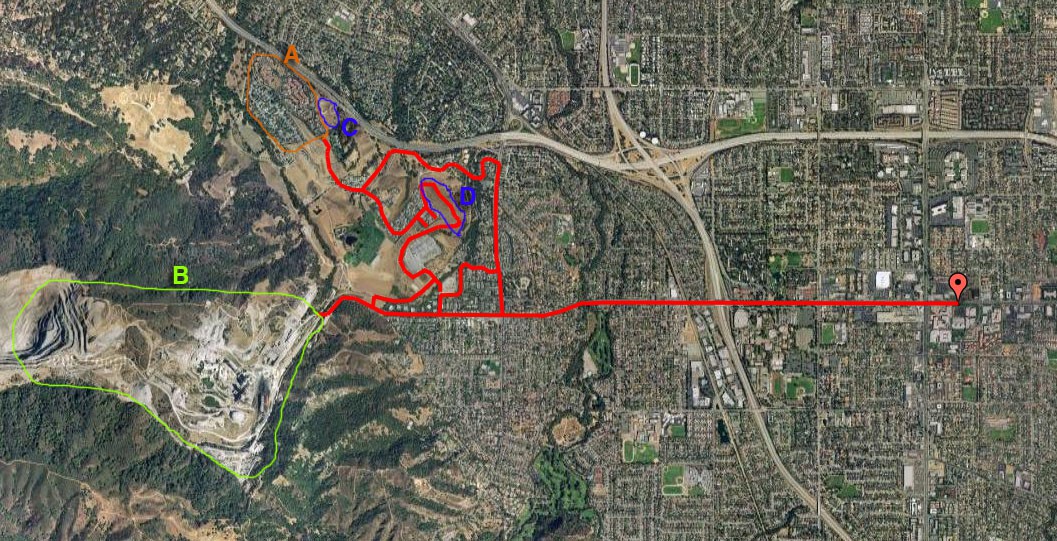
Let’s start with a map.

So, my attempts to get up into the hills dashed, I backtracked down to what I assume is Monta Vista (going by the sign on the fire station), then headed north. I wound my way up to Rancho San Antonio, marked as A (more or less). It’s quite disturbing, really… an entire town that’s a retirement village. It does have some nice houses though, and is in a pretty spot, with some view over the valley and towards the bay. There’s a few benches in the area C from which there’s quite a view.
I then decided to head back, but got sidetracked along the way by the opportunity to climb the big fat hill that had previously blocked my view (D on the map). The view from there was fantastic – a full 180 degrees north to south, out across the valley.
It’s very odd that the mountains to the east of the valley are largely bare, bar only grass, while the ones west are quite wooded.
And so anyway, long story short I returned home, via a few other minor detours – I got completely lost in the area near the electrical substation (the grey square southwest of D). Eventually I found the train track which led me back to a road, and from there it was smooth sailing back home.
What the map doesn’t show is just how hilly the area is. It’s all over the place. It was quite a tough ride. I’ll look for another way into the mountains, but I’m having mixed feelings about the ride into them. :)

